Author: Aimee
The automotive industry will face unprecedented changes in the field of autonomous driving, which not only involves significant updates to the required features during the driving process, but also includes major changes in the architecture design solutions for the entire driving system development process. One important aspect of this is high-precision maps, which are crucial for positioning and navigation, and will also undergo major design changes. This is mainly reflected in the following important areas:
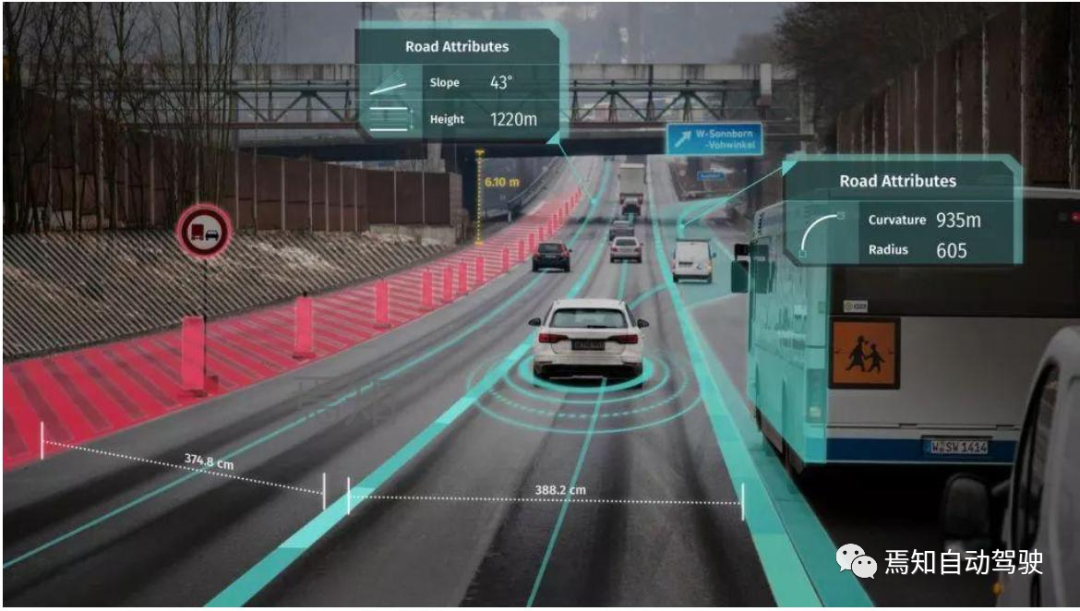
1) The deployment of roadside maps requires more strong support from government infrastructure agencies, including V2I-like vehicle-to-everything (V2X) systems that provide V2X scene rendering software development kits (SDKs) to support customized rendering styles and personalized V2X applications on the vehicle side. Using the roadside information channel (PC5), this can solve the problem of map service impact caused by cellular network coverage blind spots.
2) Real-time distribution of maps has been upgraded from seconds to millisecond level, and the ability to update and distribute high-precision maps tends to be edge-deployed, achieving real-time map updating and millisecond-level data distribution services to improve the timeliness of transmission.
3) The real-time high-precision map platform in the autonomous driving system is gradually transitioning from a distributed system to a centralized system. The high-precision map engine can provide real-time high-precision map application services for autonomous driving systems, helping to improve autonomous driving vehicle-side applications.
4) Maps need to establish more self-learning mechanisms, including establishing self-learning maps under shadow mode, and continuously updating the map’s understanding and learning of the environment.
5) Optimized maps redefine autonomous driving features, which is actually the iterative process of continuously updating autonomous driving features based on maps.
6) Provide diversified basic map services.
In the future, high-precision maps will be continuously optimized and updated to provide corresponding management services and technical advantages, including perfect functional iteration, system data security, support for multiple types of data, authorization for multiple terminals, high-quality service and operation systems, and online data update services.
The perfect functional indicators include: data distribution, collection, subscription, notification functions, dynamic data online compilation, visual online display editing, Campaign, Map Learning crowdsourcing updates, data simulation platforms, etc.
Multi-data support includes: version static layer, effective dynamics data support, flow data support, OSO custom data support, incremental data release updates, and map data integrity guarantee.
System data security includes: perfect network security configuration, firewalls, VPC, multi-level system permission management, user, role, permission, resource, https two-way encryption, data signature, HSM device integration.
Multiple terminal authorization support includes: OAuth2 authentication management, massive concurrent response, Auto Scaling dynamic expansion and contraction, complete API SDK development kit support, 2V terminal development kit and function integration, OTA update, VCDN, ensuring data security and speed.
7) V2X high-precision map service that supports edge computing
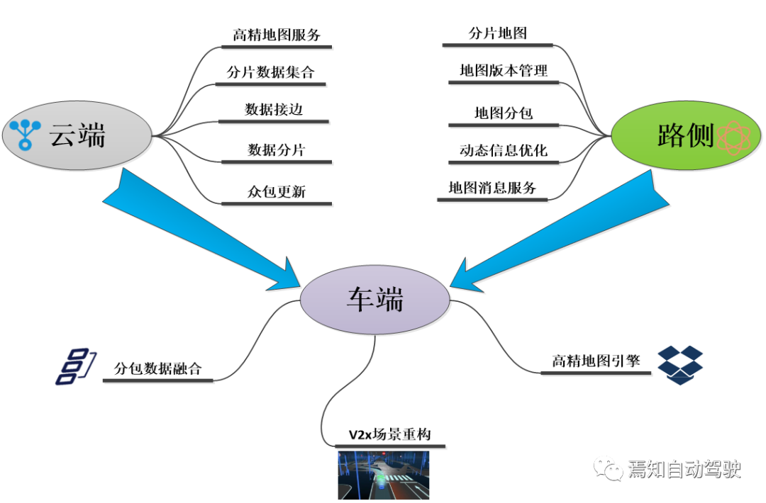
The future development of autonomous driving mainly focuses on two directions: intelligence and network. The focus is to gradually transition from vehicle-side intelligence to road-side and even cloud-side intelligence. Regarding the deployment of high-precision maps, the most important points are the series of upgrades and changes that occur on the cloud, roadside and vehicle sides. Among them, cloud-side changes mainly involve high-precision map services, shard data aggregation, data edge access, and data sharding. Roadside mainly involves shard map crowdsourcing updates, map version management, map sharding, roadside dynamic information optimization, map message services, and other aspects. When applied to the vehicle side, it requires updates to the shard data fusion, V2X scene restoration, and high-precision map engines.
The above iterative update process of the map can be applied to achieve L4/L5 level autonomous driving function, generate related robot control modes, and also be deployed in commercial vehicles to ultimately achieve autonomous driving and even remote driving.
## High-precision fusion positioning solution for mass production
Obviously, in order to achieve accurate positioning and continuously improve its functional performance, high-precision maps must continuously optimize their own fusion positioning solution. This process includes two main software algorithms. One is to perform dynamic optimal estimation of the vehicle pose through full-state-extended Kalman filtering. The second is to use visual sensors to obtain semantic information of the road environment, and use accurate map matching algorithms to obtain accurate position. In addition, economic, adaptability, and overall performance need to be improved. By choosing to configure industrial-grade vehicle terminals RTK: using high-performance industrial-grade 32-bit processors, built-in high-precision RTK boards; establishing channels with differential servers through 3G/4G/5G and Qianxin platform, sending GGA information to the differential server, and then outputting accurate position information through RS232 after receiving differential information.
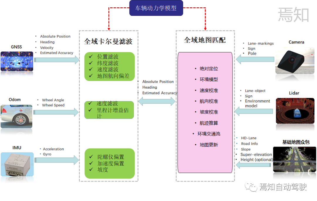
By selecting consumer-grade sensors, such as cameras and lidars integrated in the vehicle for use in location fusion (such as visual SLAM and lidar SLAM), the positioning performance is improved. For highly adaptable solutions, a unique hardware adaptation layer (such as an independent domain controller system) and a software adaptation layer (such as a standard C language interface) are mainly used to avoid platform dependencies. In high-performance requirements, the output mainly involves the positioning of both lateral and longitudinal demands. Typically, the lateral positioning error requirement is 20cm, the longitudinal positioning error requirement is 1m, and the heading angle positioning error is 0.5°. At the same time, the signal loss rate of GNSS in the longitudinal positioning error should be less than 0.3%. In addition, it is also necessary to support an external IMU with a frequency of 1000Hz and a camera input scheme with a frequency of 50Hz.
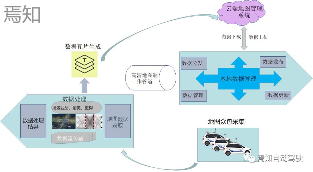
Apart from map architecture settings, the data publishing mode also requires the minimum flow cost to complete high-precision map updates, and supports streaming incremental publishing. This process includes streaming of appropriate tiles, incremental update of data, browsing rich data sets, distinguishing directories, hierarchical structures, and tiles, and achieving layered queries. Finally, cloud-based historical data can be retrieved on demand, allowing tracking of any version information.
Map Distribution and Map Packaging
The most important process for high-precision maps is the collection and distribution of map crowdsourcing. Regarding the collection of crowdsourced map data, it can be understood as the road data collected by users through the vehicle’s own sensors or other low-cost sensor hardware, transmitted to the cloud for data fusion, and improving data accuracy through data aggregation to complete the production of high-precision maps. The whole crowdsourcing process actually includes physical sensor reports, map scene matching, scene clustering, change detection, and updates.
Where Is the New Architecture for Autonomous Driving Based on Maps Going?
The current high-precision map architecture of autonomous driving systems still faces distributed development, focusing on map crowdsourcing, map box decoding of high-precision map original information, and how the map fuses other sensor input data. Here, we should note that the future architecture of autonomous driving systems will evolve from distributed development to centralized development. The centralized approach can be seen as a two-step process:
Step 1: Centralized control solution for smart driving domainTranslate the following Chinese text into English Markdown text in a professional manner, retaining the HTML tags inside Markdown, and only output the corrected and improved parts without explanations.
The intelligent driving ADS and intelligent parking AVP systems are centrally controlled and fused, predicted, and planned through a central preprocessing device that integrates the information that needs to be processed in both systems. Moreover, the processing methods of all sensing and data units related to intelligent driving and intelligent parking, such as high-precision maps, lidar, fully distributed cameras, and millimeter-wave radars, will also be fused into the central domain control unit.
Step2: Fully centralized control scheme of the intelligent driving domain and intelligent cockpit domain
This approach is the second phase of achieving a fully centralized distributed approach, which merges all the functions of the intelligent driving domain controller (such as automated driving and automated parking) and all the functions of the intelligent cockpit domain (including driver monitoring DMS, entertainment system iHU, instrument display system IP).
Step3: Fully centralized control scheme of the intelligent vehicle domain
Here we achieve full fusion control of the three major functional domains, namely, intelligent driving, intelligent cockpit, and intelligent chassis domains. The three main functional domains are integrated into the central control unit of the whole vehicle, requiring more performance (computing power, bandwidth, storage capacity, etc.) of the domain controller in the later stage for data processing.
Here, we are particularly interested in the development of high-precision map positioning, which will be more oriented towards the centralized design in the future. We will elaborate on this in detail.
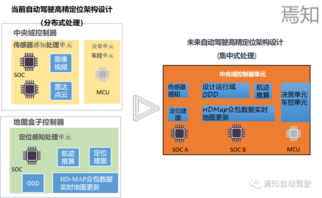
The above figure illustrates the development trend of the architecture of high-precision maps in future automated driving system controls. Future automated driving systems will strive to integrate perception units, decision units, and map positioning units into the central domain control unit, aiming to reduce dependence on high-precision map boxes from the bottom up. The design of its domain controller fully considers the integration of AI computing chips SOC, logic computing chips MCU, and high-precision map boxes.
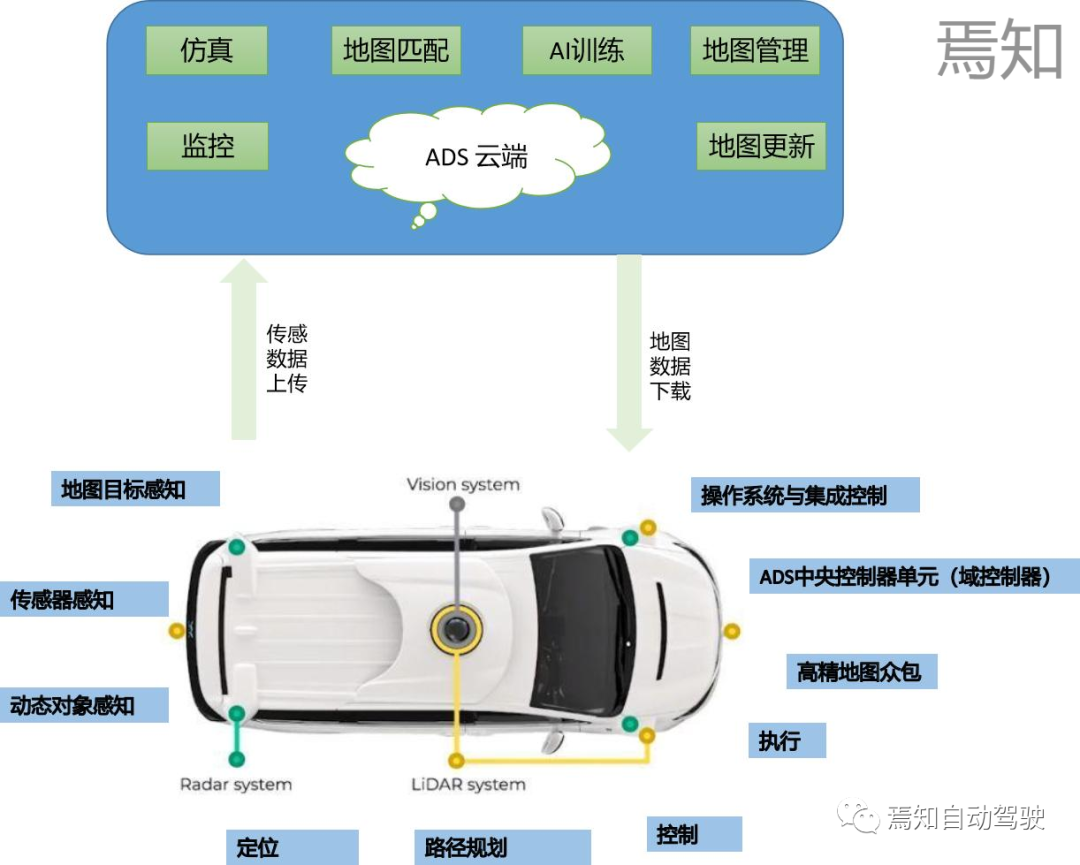
The figure above shows the respective businesses of high-precision map sensor data collection, data learning, AI training, high-precision map services, and simulation under the entire cloud control logic. Meanwhile, during the mobile and verification process of the vehicle end, physical perception, dynamic data perception, map target perception, positioning, path planning, and other contents will continuously update map data and upload the overall crowd-sourced data to the cloud through OTA.
The above passage has described the process flow of how high-precision map data is generated for the automated driving controller to process. We know that the original data processed by high-precision maps is EHP data, which actually includes the following main data supports:
-
Externally received GPS location information;
-
Matching location information to the map;
-
Establishing road network topology information;4. Sending data through CAN;
-
Fusion of partial navigation data;
This data is usually processed directly from the HDMap perception end by gigabit Ethernet and input to the central processing unit of the high-precision map. We call this central processing unit the “high-precision map box.” Through further processing of the data by the map box (the actual processing process will be explained in detail in subsequent articles), it can be transformed into EHR data (actually CanFD) that can be processed by the autonomous driving controller.
For the next generation autonomous driving system, we are committed to integrating high-precision map information into the autonomous driving domain controller for overall processing. This process means that our autonomous driving domain controller needs to connect all the data parsing work that the map box needs to perform. Therefore, we need to focus on the following points:
1) Can the AI chip of the autonomous driving domain controller process all the sensor data required by high-precision maps?
2) Does the logical computing unit of the high-precision positioning map have sufficient computing power to perform sensor data fusion?
3) Does the entire underlying operating system meet the functional safety requirements?
4) What kind of connection between the AI chip and the logical chip can ensure the reliability of data transmission, Ethernet or CanFD?
To answer the above questions, we need to analyze the way the controller processes high-precision map data shown in the following diagram.
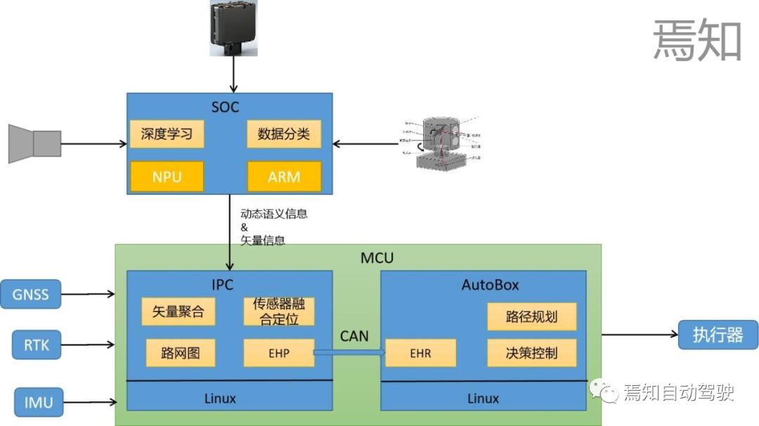
SOC, as the AI chip of the autonomous driving system, mainly undertakes the basic processing of sensor data, including camera data, lidar data, millimeter-wave data, etc., in future high-precision map data processing. In addition to basic data point cloud fusion and clustering, common deep learning algorithms are also used, and central processing is generally performed using ARM cores.
MCU, as the logical computing unit of the autonomous driving domain controller, will subsequently undertake all the logical calculation required by the original high-precision map box. This includes front-end vector aggregation, sensor fusion positioning, establishment of road network maps, and most importantly, replacing the original map box function to convert EHP information into EHR signals (how the central processor MCU effectively converts EHP information into EHR information will be explained in detail in subsequent articles), and effectively transmitting the signal through the Can line. Finally, path planning, decision control, and other operations are conducted using the AutoBox logical computing unit.
SummaryThe future of autonomous driving will tend to integrate all data processed by high-precision maps into the domain controller of autonomous driving from the original map box, aiming to establish a true central processing fusion with the entire vehicle domain controller as the integration unit. This way can not only save more computing resources but also enable AI data processing algorithms to be better applied to high-precision positioning, ensuring the consistency of both in environmental awareness. We need to pay more attention to the important direction of high-precision sensor data fusion in chip computing power, interface design, bandwidth design, and functional safety design in the follow-up.
This article is a translation by ChatGPT of a Chinese report from 42HOW. If you have any questions about it, please email bd@42how.com.